Back to the index
Glossary and Acronyms: S
SAB:
Satellite Analysis Branch (NOAA/NESDIS). The Satellite Analysis Branch serves as the operational focal point for real-time imagery products and multi-disciplinary environmental analyses within NESDIS. The Branch provides tropical cyclone analysis, positions and intensities based on the Dvorak technique.
Saffir-Simpson scale:
a scale that links the observed damage and the effects of wind, pressure and storm surge that could lead to such damage. Initial wind damage scale was defined by Herbert Saffir and later expanded by Robert Simpson to include storm surge.
| Classification |
Category 1 |
Category 2 |
Category 3 |
Category 4 |
Category 5 |
|---|
| Pressure (hPa) |
> 980 |
965-979 |
945-964 |
920-944 |
< 920 |
| Wind (km/h) |
118-153 |
154-177 |
178-209 |
210-249 |
> 249 |
| Wind (knots) |
64-83 |
84-96 |
97-113 |
114-135 |
> 136 |
| Damage |
Minimal |
Moderate |
Extensive |
Extreme |
Catastrophic |
Saffir-Simpson scale
Scatterometer:
a specialized microwave radar designed to measure surface winds (direction and intensity) over the oceans from an orbiting satellite. To do so, the scatterometer uses algorithms relating the wind to the backscattering cross section σ0.
Sea state :
local state agitation of the sea due to the combined effect of wind and swell.
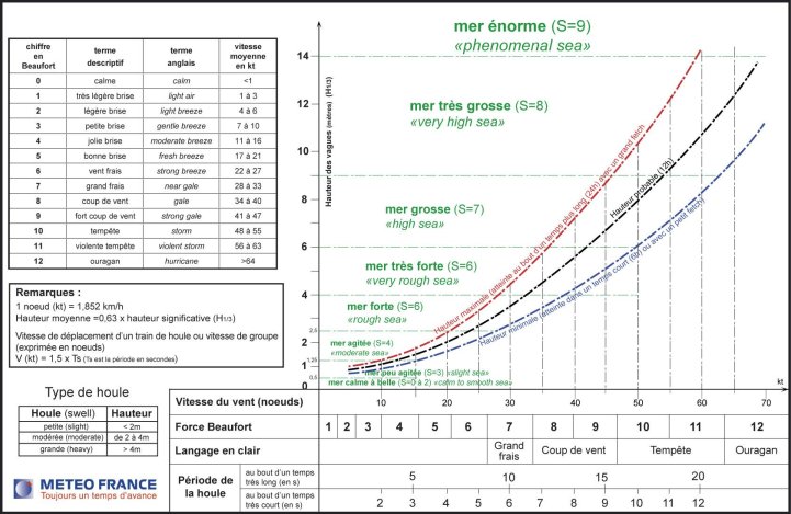 Sea state and swell, functions of the wind speed.
Beaufort scale.SD :
Subtropical Depression.
Short-range forecast:
A forecast whose period of validity is less than about three days (period of validity of nowcast or very-short-range forecast prevision is not more than 12 hours).
Size (of a cyclone):
extension of a tropical cyclone clockwise circulation, arbitrary given by the extension of the near gale winds or first closed isobar radius.
SLP:
Sea Level Pressure.
Southern Oscillation:
Originally defined in 1924 by Gilbert Walker as a low-latitude, planetary- scale "seesaw" in sea level pressure, with one pole in the eastern Pacific and the other in the western Pacific-Indian Ocean region.
The pressure seesaw is associated with a global pattern of atmospheric anomalies in circulation, temperature, and precipitation. The primary timescale of the oscillation is interannual-multiyear, and it is now recognized to be primarily a response to basin-scale sea surface temperature variations in the equatorial Pacific arising from coupled ocean-atmosphere interactions, the opposite extremes of which are the El Niño and La Niña warm and cold events. See also ENSO.
Special Emergency Plan "cyclone":
Specific to La Reunion Island. This plan is intended to inform the population of the risks in case of cyclonic threat, to issue appropriate security regulations, to make use of precautionary measures and to forecast and coordinate extreme emergency rescue for people in difficulties. It defines the cyclone phenomenon and its hazards, different warning stages (cf. "warning system") and responsibilities of each state service, of communes and of media when a tropical storm or a tropical cyclone occurs. In this plan, the term "cyclonic conditions" means that average winds reach 100 km/h or more, with gusts reaching 150 km/h or more.
Special Emergency Plan "Dangerous Meteorological Events":
in use in May 2007 in La Reunion Island, replacing the special plan "heavy rains" existing since 1991. It is independent of the plan "cyclone" and may be activated in the same time. It includes four typical meteorological events which affect regularly La Reunion Island: heavy rains, thunderstorms, strong winds and heavy swells. The plan defines some levels of risk for each event.
Decisive thresholds associated with each phenomenon are:
- Heavy rains: 70 mm in 3 hours, 100 mm in 6 hours, 150 mm in 12 hours, 200 mm in 24 hours ;
- Strong winds: gusts between 100 and 150 km/h;
- Strong swells: for polar swells or trade winds swells, h1/3
> or = 4 m (maximum height can reach the double of the indicated value). There is no threshold for the cyclonic swells.
This plan defines two levels of warning:
- The meteorological vigilance (heavy rains, storms, strong winds and heavy swells), activated by Météo-France, aiming to inform of the risk the state services, communes and population, and to encourage population to take suitable precautions;
- The safeguard stage, activated by the prefect in case of widespread damage in a part or everywhere in the Island. Its aim is to preserve the physical integrity of the population and to organize suitable intervention of services and local communities.
Spout:
a phenomenon consisting of an often violent whirlwind, revealed by the presence of a cloud column or inverted cloud cone (funnel cloud), protruding from the base of a Cumulonimbus, and of a "bush" composed of water droplets raised from the surface of the sea or of dust, sand or litter, raised from the ground. A spout at its height is a tornado. A tuba (tub), less intense, is a cloud or inverted cloud cone, protruding from a cloud base; it is a cloudy manifestation of a more or less intense vortex. This supplementary cloud feature occurs with Cumulonimbus and, less often, with Cumulus.
Squall:
A strong wind characterized by a sudden onset, a duration of the order of minutes, and then a rather sudden decrease in speed. it is often accompanied by showers or thunderstorms. In nautical use, a squall is a severe local storm considered as a whole, that is, winds and cloud mass and (if any) precipitation, thunder and lightning.
A squall line is a line of active thunderstorms, either continuous or with breaks, including contiguous precipitation areas resulting from the existence of the thunderstorms. The squall line is a type of mesoscale convective system distinguished from other types by a larger length-to-width ratio.
SSMI:
Special Sensor Microwave Imager. The SSM/I is flown aboard Defense Meteorological Satellite Program (DMSP) satellites F8, F10, F11, F12, F13, and F15. The SSM/I is a passive microwave radiometric system that measures atmospheric, ocean and terrain microwave brightness temperatures at 19.35, 22.2, 37.0, and 85.5 GHz.
SST:
Sea Surface Temperature.
Standard_atmosphere, reference atmosphere:
atmosphere chosen to represent the approximate average distributions of pressure, temperature and density in the vertical.
Steering flow:
atmospheric current that strongly influences the movement of the tropical systems. It is generally situated in the middle or upper troposphere. Weak tropical systems are under the influence of the steering flow created by centres of action located in the low to mid levels whereas strong tropical systems are under the influence of the steering flow created by centres of action located in the mid to high levels.
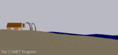
Storm surge:
Storm surge is an offshore rise of water associated with a low pressure weather system, typically a tropical cyclone. Storm surge is caused primarily by high winds pushing on the ocean's surface. The wind causes the water to pile up higher than the ordinary sea level. Low pressure at the center of a weather system also has a small secondary effect (see inverted barometer effect).
This advancing surge combines with the normal tides to create the tropical cyclone storm tide, which can increase the mean water level 4 to 5 meters or more. This rise in water level can cause severe flooding in coastal areas, particularly when the storm tide coincides with the normal high tides.
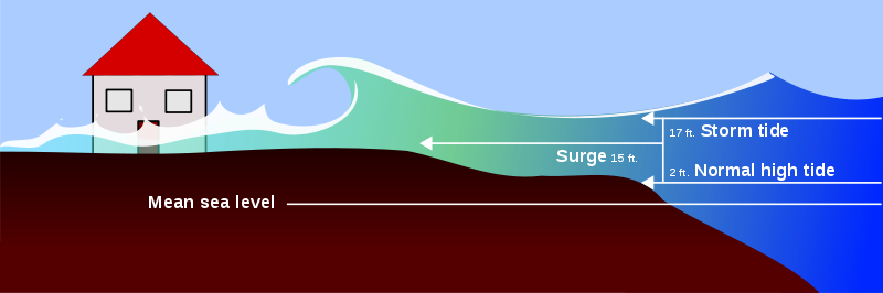
The level of surge in a particular area is also determined by the slope of the continental shelf. A shallow slope off the coast (bottom, left picture) will allow a greater surge to inundate coastal communities. Communities with a steeper continental shelf (bottom, right picture) will not see as much surge inundation, although large breaking waves can still present major problems. Storm tides, waves, and currents in confined harbors severely damage ships, marinas, and pleasure boats.
Storm tide :
abnormal increase in height of the average sea level along the coasts in relation with a cyclone. Is the result of the sum of the astronomical tide and of the storm surge.
Streamline:
a line which is tangent at any point in a fluid parallel to the instantaneous velocity of the fluid at that point.
Stratosphere:
region of the atmosphere, situated between the tropopause and the stratopause, in which the temperature generally increases with height.
Subsidence :
Slow descent of mass of air, aver a wide area, generally accompanied by horizontal divergence in the lower layers. The subsiding air is compressed and warmed and its initial stability is generally increased. A subsidence inversion is a temperature inversion caused by the adiabatic warming of a layer of subsiding air.
Subtropical anticyclone:
(or subtropical high-pressure belt).
Series of high pressure cells aligned approximately along the 35° parallele in each hemisphere. The axis of each belt has a small, annual, meridional fluctuation.
Subtropical depression:
low-pressure system existing in the tropical or subtropical latitudes (anywhere from the equator to about 50°N/S) that has characteristics of both tropical systems and mid-latitude (or extratropical) systems.
Therefore, many of these systems exist in a weak to moderate horizontal temperature gradient region (like mid-latitude cyclones), but also receive much of their energy from convective clouds (like tropical cyclones). Often, these storms have a radius of maximum winds which is farther out (on the order of 100-200 km from the center) than what is observed for purely "tropical" systems. Additionally, the maximum average surface winds for sub-tropical cyclones have not been observed to be stronger than about 50 kts [92 km/h].
Sometimes these subtropical storms transform into true tropical cyclones. This transformation is rather frequent over the Atlantic basin - Hurricane Florence in November 1994 is a recent example - but is much more uncommon over the Southern Indian Ocean (an example could be the system nr 11 in June 2001). These systems are monitored and RSMC issues forecasts and warnings similar to those for tropical systems. Now they are given names from the tropical cyclone list.
(See FAQ A4)).
Sun-synchronous satellite:
satellite in an orbit whose plane is fixed relative to the Sun, permitting the satellite to obtain views of a given geographical area at the same local time each day. A sun-synchronous satellite always crosses the equator on the ascending node at the same local solar time.
Surface wind:
wind blowing near the Earth's surface. It is measured, by convention, at a height of 10 m above ground in an area where the distance between the anemometer and any obstruction is at least 10 times the height of the obstruction.
Swell:
any system of water waves which has left its generating area.
SWIO:
South West Indian Ocean. Area of responsibility of the RSMC La Réunion, from the african coastline to the 90°East, and from the equator to 40°South.
Synergie:
Forecaster's workstation, software package allowing to display all the meteorological data useful to the forecaster- satellite imagery, radar imagery, numerical models outcomes, observations -and produce weather reports. This system was developed by Meteo-France and it is used in many countries.
Synoptic hour:
Hour (UTC), determined by international agreement, at which meteorological observations are made simultaneously throughout the world.
Synoptic scale:
The scale of the high -and low- pressure systems of the lower atmosphere whose typical dimensions range approximately from 1000 to 2500 kilometres.